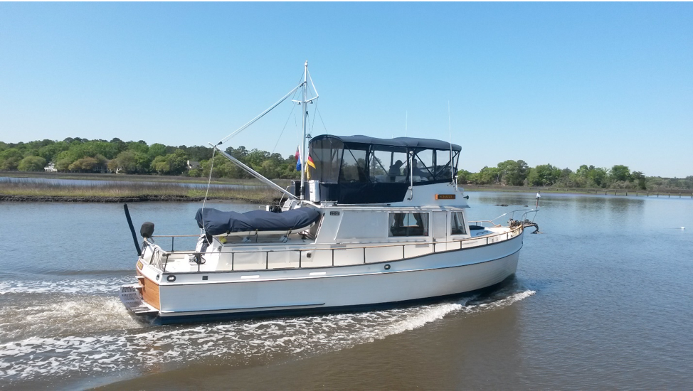
Let’s Take a Virtual Cruise
Cruising Ideas for the Upper and Middle Chesapeake Bay
La Trappe Creek to Oxford MD
A Bald Eagle pair flies off ahead of you as you glide along La Trappe Creek. The beginning of an adventure in quiet places, historic places, or just in the marsh up a creek. Make sure your kids leave their phones below and make this part of the trip on the flybridge, there is a lot to see here. Our early spring has brought trees into bloom against the contrast of still bare ones. The geese are pairing off. Birds are busy everywhere, and farm fields are losing their emerald coats to the plow. The lighthouses at the entrance are very old. Your first destination is Oxford, just around the corner really, where dockage at OYA puts you right in town. Oxford was the first official seaport in the Chesapeake Bay, established and laid out in 1683. A great walking town, Oxford is a place to see beautiful period homes and gardens. Down the street is the Oxford Market, where you can buy convenience items and get a delicious sandwich or warm lunch special from Eileen’s Deli. There remain several working boatyards and boat builders in Oxford which harks back to the town’s beginnings. A quarter-mile in the opposite direction from OYA is Latitude 38. An Oxford favorite, this restaurant is currently offering carryout service.
NAVIGATION: Leave Dickerson Harbor during the last third of the rising tide. The channel is marked with small red nuns and cans, remember to leave red to port as you follow the channel. Departing the creek, leave the outer black can light to starboard and at about 310 degrees, you will intersect the main channel of the Choptank River Channel of red nuns and red bell bouys. Leave the red day marker off Castle Haven well to port and you will find the “tank” aspect of the Choptank, up to 65 feet in depth! Once past Chlora Point head for red #14 and the Choptank River on a course of about 300 degrees from flashing Red 18. Leave Green 1 (daymarker) to port on a northerly course at the mouth of the Tred Avon River. Continue on a northerly course up the Tred Avon. The Oxford harbor entrance is to starboard before Red 2. Follow Town Creek Channel at 5 knots all the way to the end (approx. .5 mi) and you will see Oxford Yacht Agency on you starboard side.
Oxford to Tilghman Island
Lately a destination for great seafood restaurants and sport fishing, Tilghman Island is one of the oldest communities on The Bay. It has been inhabited by farmers and watermen since 1656. Some of the remaining skipjack fleet berth here. The Watermen’s Museum offers a history of the island and of the fishing industry on The Bay. Tilghman Isaland was very isolated for hundreds of years and sometimes you can still hear the local dialect that developed here. There is a kayak trail around the island where you can view wildlife in areas only accessible by small boat. See the Waterway Guide for dockage choices and call ahead for reservations. There is no safe anchorage here for overnight unless you go to Dun Cove, just around Eagle Point north of Knapps Narrows.
NAVIGATION: Follow Town Creek Channel out of Oxford. Follow the creek outto the Tred Avon River to Green 1, make your turn to starboard at least ½ mile past the mark to avoid shoals off Benoni Point. Head for red 2 (approx. 288 degrees) to get lined up for Knapps Narrows. Call ahead for up to date depths in the narrows; Knapps narrows Marina (410-886-2720) or Tilghman Island Marina (410-886-2500). Study the chart and marks carefully as you approach because the marks for Dogwood Harbor and Knapps Narrows can be hard to differentiate. Leave flashing Red 2 to starboard, then pick up flashing Green 3 at the narrows entrance by steering slightly east of North. The channel is narrow, so stay on your marks (red on right) and try to enter when there are no other boats exiting. The Knapps Narrows Bridge is well tended and you may not need to call to get it opened if you are travelling through the Narrows. Note that the marks reverse after the bridge so it is red on right returning at both ends of Knapps Narrows.
Tilghman Island to St. Michaels
The Chesapeake Bay Maritime museum is truly one of the treasures off the Chesapeake. On the waterfront of St. Michaels. The museum offers a closer look at the history and vessels of The Bay. There is a “floating fleet” of various traditional Bay workboats, a working shipyard, a lighthouse, and many exhibits pertaining to regional history and ecology. Dockage at the museum is available only to member, but there is anchorage off the museum. Note there are two harbors here; the first is Fogg Cove where you will find the museum and anchorage. The main area for dining and dockage is the main harbor just south of Fogg Cove. St Michaels also offers some unique shopping and a market.
NAVIGATION: Continue northwest through Knapps Narrows to flashing Green 1 on the west end of the Narrows. Turn to starboard to approximately 346 degrees and head for Green 3 and enter Poplar Island Narrows. At Green 3 turn to North and head through the channel following the marks closely. Follow the channel to Red nun 2 and turn to approximately 60 degrees. Pass (red) bell 2A and continue at 60 degrees to flashing Red 4 off Tilghman Point. Here you enter the Miles River with a turn to starboard keeping Red nun 6 to starboard. Steer a course of approx. 155 degrees from nun 6 to nun 8. From there follow the channel markers into St. Michaels. The restored Hooper Straight Lighthouse sits on the museum grounds and is an obvious landmark.
St. Michaels to Wye Island
The Wye River is known to have some of the best crabbing and fishing on Chesapeake Bay, and it is just about time for our world renown blue crabs! Between the Wye River and Wye East River is Wye Island. Wye Island is home to Wye River Natural Resource Management Area offering hiking trails, picnic areas, and a quiet and protected refuge. Get to know some of the unique habitat of The Bay that has attracted waterfowl and spawning fish for millennia. Boaters are welcome to come ashore at the management area, just be thoughtful and choose a gently sloped area to beach your dinghy and cause minimal disturbance to the shoreline.
NAVIGATION: leave St. Michaels via the marked channel to Red nun 10. Turn to starboard and leave Green can 1 to port, then Green 3 to port and flashing Red 4 to starboard. To enter the Wye East River follow the coastline around the bluffs on your starboard side. There are excellent depths in the middle of the river up past Wye Island.
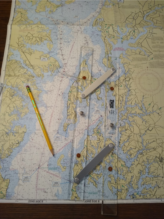
Charting a course through Poplar Island Narrows. Always use pencil to mark your charts, and write the heading above your pencil line so you never have to find it again, and can reverse it easily when travelling in the opposite direction. Double check the chart along your course line for adequate depths.
Dickerson Harbor to Slaughter Creek
If you have the desire to get into nature right away, one alternative is to go down the bay to the Little Choptank River and Slaughter Creek for some gunkholing in the marshes. From there it is a 5.5 to 6 hour cruise to Hooper Straights where you have the option to navigate either the Nanticoke or Wicomico Rivers.
NAVIGATION: Follow the red nuns and black cans out of La Trappe Creek. At flashing Green 1 head towards Red nun 18A at a heading of approx. 290 degrees. Here you turn just 5 degrees to starboard and pick up flashing Red 14. At Red 14 set a course of approx. 301 degrees to Red 12A, then 273 degrees to Red 10, 233 degrees to Red 6 and Green 5. A heading of approx. 160 degrees with take you to flashing Green #1 which you will leave to port. Then turn to approx. 140 degrees to run to flashing Green 5, leaving it to port also. From Green 5 turn to approx. 175 degrees which will take you to flashing Red 2SC and the entrance to Slaughter Creek. Follow the marked channel into the creek. The Taylor island Bridge has a clearance of only 10 feet, so anchor and take the dinghy the rest of the way up. Refer to the Waterway Guide Chesapeake Edition.
The Waterway Guide has sections to read about the Nanticoke and Wicomico Rivers in Chapter 4. The Nanticoke River runs up to Seaford DE through some beautiful and wild areas. I once saw cows cooling themselves in the River! The Wicomico River runs up to Salisbury MD. Both these rivers are navigable up to these destinations with good water all the way. Once through Hooper Straight and into Tangier Sound you can get to the mouth of either river.
Slaughter Creek to Hoopers Straight
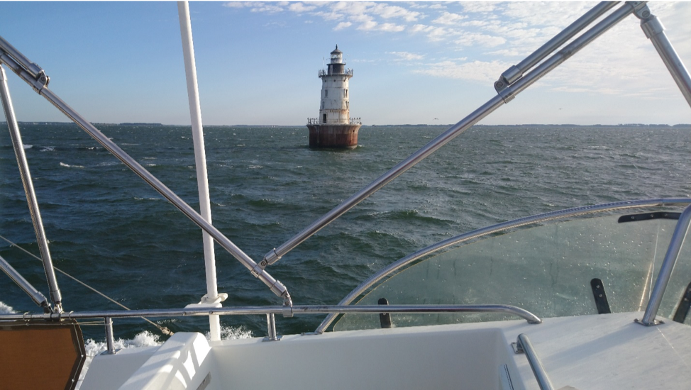
NAVIGATION: Reverse your course out of Slaughter Creek and out into the Little Choptank River. From flashing Green 3 steer approx. 320 degrees to Red nun 4. Turn to 195degrees and go to Red nun 2. From Red nun 2 steer 175 degrees to flashing Yellow J1. Turn to approx. 190 degrees to Red & White CP, this jog avoids the fish traps to port. Steer approx. 160 degrees past flashing Red 76 and continue on course to flashing Red 74. From here steer approx. 140 degrees to flashing Green Bell 1. You will pass Hooper island Lighthouse on your starboard side. From Green Bell 1 steer 70 degrees to Hooper Straight Light. From Hooper Straight Light you will see the Hooper Straight Channel markers (red on right returning). Follow the channel to flashing Red 4. From flashing Red 4 you can chart a course to either the Nanticoke or Wicomico River.